

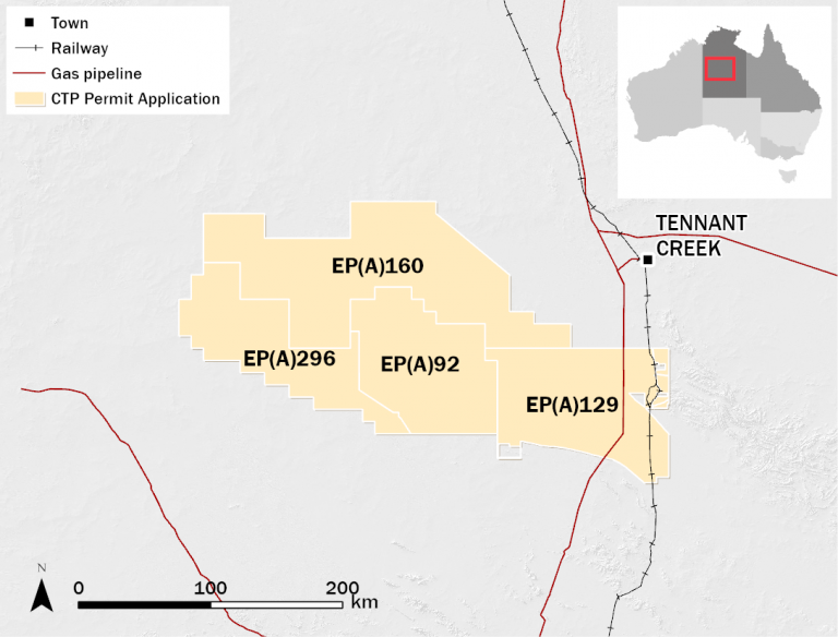
Tenement Information
| Tenement | Area (km²) | Location | Operator | CTP Consolidation Entity | Other JV Participants | ||
| Registered Interest (%) | Beneficial Interest (%) | Participant Name | Beneficial Interest (%) | ||||
| EP(A) 92 | 8,512 | Wiso Basin NT | Central | 100 | 100 | – | – |
| EP(A) 129 | 9,792 | Wiso Basin NT | Central | 100 | 100 | – | – |
| EP(A) 160 | 15,309 | Wiso Basin NT | Central | 100 | 100 | – | – |
| EP(A) 296* | 7,547 | Wiso Basin NT | Central | 100 | 100 | – | – |
* Excised from EP(A) 92
Description and Geology
The Wiso Basin covers some 160,000km², with the Lander Trough (30,000km²) at the southern margin dipping southwards, and terminating against the Arunta Block. Current gravity modelling indicates northwest to southeast trending depocenters in the Lander Trough to contain 4,500 to 5,000 metres of sediments. Potential source rocks of the Montejinni Limestone have been mapped in outcrop and shallow drill holes and are thought to be analogous to the Mid-Cambrian Thorntonia Limestone in the Southern Georgina Basin. Preliminary gravity modeling suggests structure characterized by a series of terraces that parallel the southern margin of the basin. The basin is sparsely explored, with no modern seismic data and well penetrations are limited to a few stratigraphic wells up to 130m deep on the north-east margin with oil shows encountered in several of these wells.
Exploration
Gravity and magnetics data acquired by NTGS and GA up to 2013 has been interpreted and have provided estimates of sediment thickness and identified possible structures. The work program for these permits includes seismic acquisition which will be targeted at delineating structural trends such as those identified on potential field data. Wildcat exploration wells will then be drilled on the defined leads to assess the petroleum potential of the basin.