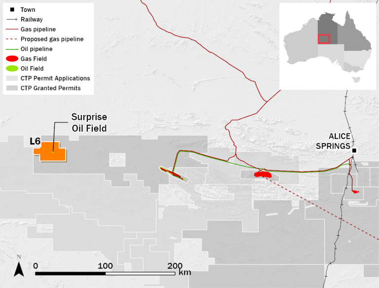
Tenement Information
| Tenement | Area (km²) | Location | Operator | CTP Consolidation Entity | Other JV Participants | ||
| Registered
Interest (%) | Beneficial
Interest (%) | Participant Name | Beneficial
Interest (%) | ||||
| L 6 | 929 | Amadeus Basin NT | Central | 100 | 100 | – | – |
Facility Details
In March 2014, a small temporary test production and storage facility was installed that allowed production to commence at the Surprise Field. Then in October 2014, a permanent production facility came on line that comprised of wellhead pumping equipment, a heater treater, oil storage, water handling and evaporation pond. Low oil prices and the remoteness of the field led to the decision to shut-in oil production from August 2015. The facilities have been mothballed to preserve the equipment for later use.
Description and Geology
In 2011, oil was discovered at Surprise 1 within the Ordovician Lower Stairway Sandstone at a depth of 2,500 metres. This discovery extends the Horn Valley Siltstone hydrocarbon fairway ~160 km west of the Mereenie Oil and Gas Field. Surprise is a doubly plunging, anticlinal trap situated on one of many northwest trends. The trap formed as the result of compression and associated salt tectonism in the underlying Neoproterozoic section. The Lower Stairway Sandstone is also productive at the Palm Valley Gas Field where the gas is primarily produced from natural fractures.
Production
The Surprise Oil Field comprises a single development well producing into a small tank farm located on the site. The production process involves pumping fluid to surface where it is separated into oil, water and gas, before storage and eventual trucking of the oil to market.
The field commenced production in March 2014 and produced approximately 87,000 barrels of oil to 30 June 2015. Low oil prices and the remoteness of the field led to the decision to shut-in oil production from August 2015. Production could recommence if oil prices recover significantly in $A terms and the reservoir displays good recharge.
Appraisal and Development
Following discovery of the oil field on 2D seismic data in 2010, Central acquired 3D seismic data in 2012 to better define and map the structure. The 3D seismic also showed that a previously mapped fault fully splits the structure in two. The undrilled eastern culmination is referred to as Surprise East.
Exploration
The licence area of 929 km² provides scope for additional leads geologically similar to Surprise on the intersection of regional northwest trending hinge lines with faults or salt bodies. The acquisition of gravity data is assisting the location and delineation of targets for future seismic acquisition within L6 and EP115. Other reservoir targets include oil or gas in the underlying Cambrian to Neoproterozoic section where larger faults and salt bodies create various trap types.
Planning is underway to drill the Mamlambo 1 well approximately 8km to the northeast of the Surprise Oil Field in the L6 permit targetting 18 mmbbl of oil (mean prospective resource) in the Lower Stairway/Pacoota on the flanks of the oil-prone Johnstone Trough.
